Welcome to my guide on Agisoft Metashape, the tool of champions.
In this multi-part guide we’re going to take a look at Agisoft’s Metashape, deep diving as much of the feature-set as I can fit in.
I’m Robert Marshall, and I work @ ElevatedVision as the Chief Pilot and founding director, with a hint of an IT background, and as of the date of this post I’ve been a UAV pilot for about 18 months.
These guides are my go at helping others that like me, began their journey needing to learn a lot very quickly, doing so by reading as much can be found online, swinging from one blog or video to another, hoovering up knowledge. I hope that this series adds to the volume of community knowledge already out there, and that there’s something in here that helps you along your way.
Some assumptions that are made for this guide are:
•You have used DJI Terra
•You haven’t used Agisoft’s Metashape but want to take a look
•You’ve gotten a smidgen of talent from using Terra, and feel ready to go to the next level
It is worth noting that as of the date of this guide, the version of Metashape that will be used is Version 2.1.0.
Apps with Skin In The Game
So far I’ve used two of the three products that I know are considered leading in the UAV industry for professional photogrammetry software, there are other apps out there such as Autodesk ReCap with its BIM features\functionality, Meshroom, and RealityCapture, some of which I will cover in another series.
Agisoft Metashape, DJI Terra and Pix4dMatic
In most cases if you have DJI equipment, especially a camera, then you received a key for a 6 month free trial of DJI Terra, and you most likely have some experience with it. What with Terra being given away like candy by DJI, I’ll assume that like me it was your first bit of professional photogrammetry software used to render 3D models, cloud points, surface models and Orthomosiac photographs.
I started out with DJI Terra after purchasing a DJI Matrice 300 RTK and Zenmuse P1 camera. Terra’s simplified interface and good-looking results make it very usable, and fundamentally it forms part of the DJI Hardware\Software eco-system. You can fly and render end-to-end using DJI technology, the documentation isn’t the greatest, the product gets regular updates, support is there on the DJI Forums if needed, and the price is competitive but it lacks broadness of functionality.
What it does really well is simplify the workflow needed to get results, appealing to the most basic of user who, with minimal hand-holding, can produce 3D models, Orthomosiacs, dense point clouds and surface (DSM) models with ease. Capable of producing good-looking results, with a small learning curve its a tool ideally suited to beginners, carrying most of what they need to do until they get to the point when they realise what’s being missed, what the others do, and in many cases do far better.
I understand that some of us don’t need to push Terra that much, all you need to do is forward on to customers the raw results Terra produces and in most cases its job done, without the need to take them into other products to tidy up or produce further materials, such as a contour map, or cleaning up cloud points to name but a few, and if that’s you then it may seem like there isn’t much point leaving Terra, but my opinion is that if you are in this business and want to be serious about it, you will want to plan to move off of Terra at some point, and into one of the bigger more feature-rich products, perhaps your license is coming up for renewal, now is a good time to consider the switch, preferably with some overlap for business continuity sake.
Pricing
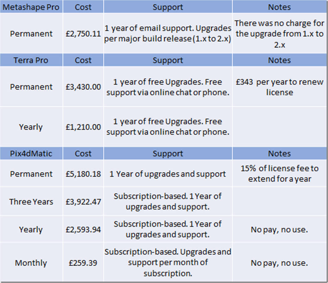
There’s two pricing models, subscription-based licensing or a permanent license. I prefer to own a product in some circumstances, and this is one of them, I see it as a long-term investment in the business, and I don’t want the engine that underpins the entire business to have a kill-switch built into it. It leaves me able to plan-in the upgrade at a time that is right for the business, and if a feature in a newer release is important enough to need, I can simply bring forwards the upgrade.
Pricing is different between all three products for both types of license, if we look at the costs for a permanent license for each product its Pix4d, Terra and Metashape, if we look at it per year its Pix4d and Terra. Metashape doesn’t do a yearly license but the concept is there, in the form of charging for major milestone upgrades. They state that to go from version 1.x to version 2.x was supposed to be chargeable, but they recently allowed their 1.x customers to upgrade for free to 2.x, meaning no one was charged to get the latest release, so their investment in Metashape continued for another year free of charge with support and updates. I’m sure they will charge to go to 3.x but that should be another year off, I expect that they will charge at the next major milestone release, I do not know if they will charge the permanent license again or a discounted upgrade charge like DJI Terra.
Pix4dMatic
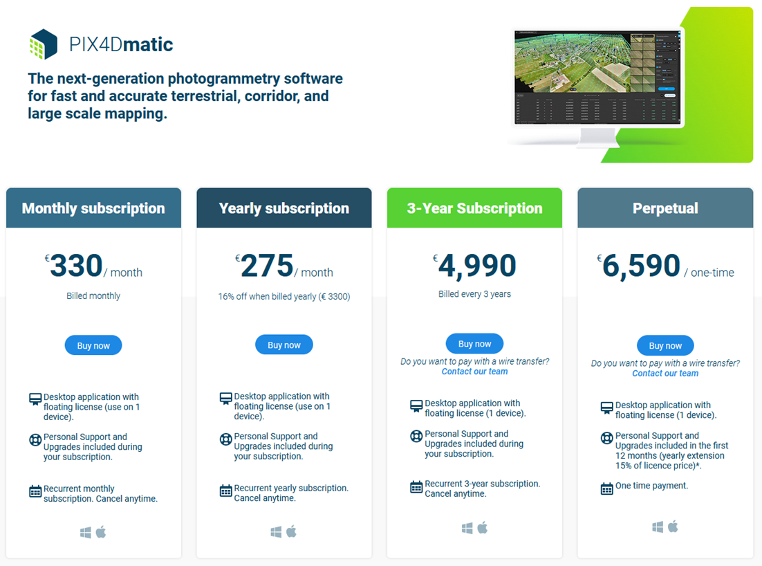
PIX4D is a family of products each with specific use-cases and license costs, the notable one being PIX4Dmatic, and PIX4DMapper, PIX4DSurvey, with perpetual and subscription-based licensing.
I have not used Pix4dMatic, I will give its trial a go at some point, I was introduced to their products by my DJI reseller and RAE, but since Terra was free for 6 months, I wasn’t ready or keen to look into it. When it came time to upgrade, I decided to go with Metashape with a bit of steer from another pilot. To be fair I could have gone either way, with Pix4d’s products being loaded with features, and the overlap is considerable in what they both do, but I liked the technical and very geeky aspects of Metashape, so went with that instead.
DJI Terra
DJI Terra is a great product, but I think its permanent license is way over-priced. Don’t even look at the price for the clustered version its eye-watering for what you get. The permanent license is over-priced because the feature-set is limited and as an application its not that versatile. It costs less than Pix4d Mapper and yet more than Metashape, while delivering less than either. There’s hardly any in-product editing, the workflow is on-rails and quite rigid, a project is often a one-time run-through affair, its great at what it does acting as a factory production line, put photo’s in, do some post-render prep work with GCP’s and Datums, configure the engine a little more, and let it render to finally manually export the results. For what it delivers the price for a permanent license is just unrealistic, I wonder if its priced so high because of the Electricity license that lights up parts of the product that remain dark with the Pro license. Aside from the Electricity edition and its value in that niche the energy industry, I think after a few posts of this guide you’re going to see how limited Terra is.
Agisoft Metashape
Agisoft offer Metashape, which can best be described as the swiss-army knife of photogrammetry software, lot of in-product tooling to cater for the phases in whatever workflow is taking place, most of it is exposed via Python and can be scripted, and it comes in two editions, with Professional being the one we’ll be focusing in on. Along the way we’ll also check out Agisoft’s Cloud service, that integrates with Metashape Professional.
I see that there is a good reason to use Terra, but its limitations overcome its usefulness over time, with exports being imported into other paid or free products to fill the gaps, and to choose between Metashape or Pix4dMatic, you are going to have to take a good look at their offerings both online (Cloud) and offline (Desktop), and make your own decision. The price shouldn’t put you off, consider how each fits within your company and existing\future workflows, its a big investment.
Next up in Part 2 we’ll begin the installation of Metashape before we get underway with an overview, we’ll look at the trial, install the product and do some post-installation configuration.



Pingback: Metashape Guide – Part 2 – EV Blog